


BY ANDY WALGAMOTT, NORTHWEST SPORTSMAN MAGAZINE
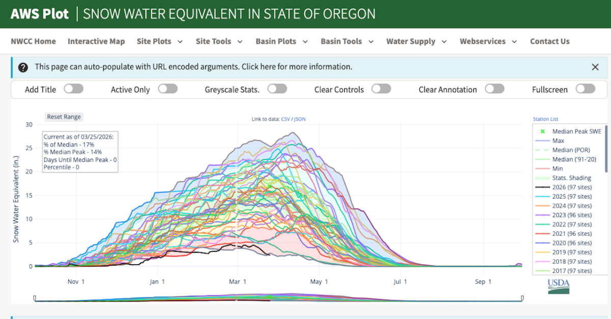
Today marks median peak snowpack for the state of Oregon, but the white stuff is going the opposite direction, setting a new all-time low for March 25, a worrisome sign for spring runoff and summer and fall flows for fish, not to mention wildfire season.
Snow water equivalent measured at 97 recording stations across the state dipped to just below where it was at this same point during the epic snow-drought winter of 2015, caused by The Blob.
Oregon’s median peak over the 30-year period of record, 1990-2020, is 16.9 inches of snow water equivalent; today’s measurement is 2.4 inches; 2015’s was 2.8 inches.
Snow water equivalent is how much standing water would result if you melted snow cover instantaneously; median is the midpoint of a set of values.
To be clear, there’s still snow in Oregon’s mountains, but there just ain’t a lot, and there never was this winter.
Things started out warm and rainy in December, picked up some snowpack around New Year’s, stalled due to a loooong dry stretch, gained a little bit of ground in February, but has begun to sputter out here in March.
It’s left nearly the entire state shaded red, meaning below 50 percent median snowpack, on the National Water and Climate Center map that tracks snow water equivalent. Washington is in a bit better shape, and still has about 11 days till it hits statewide median peak.
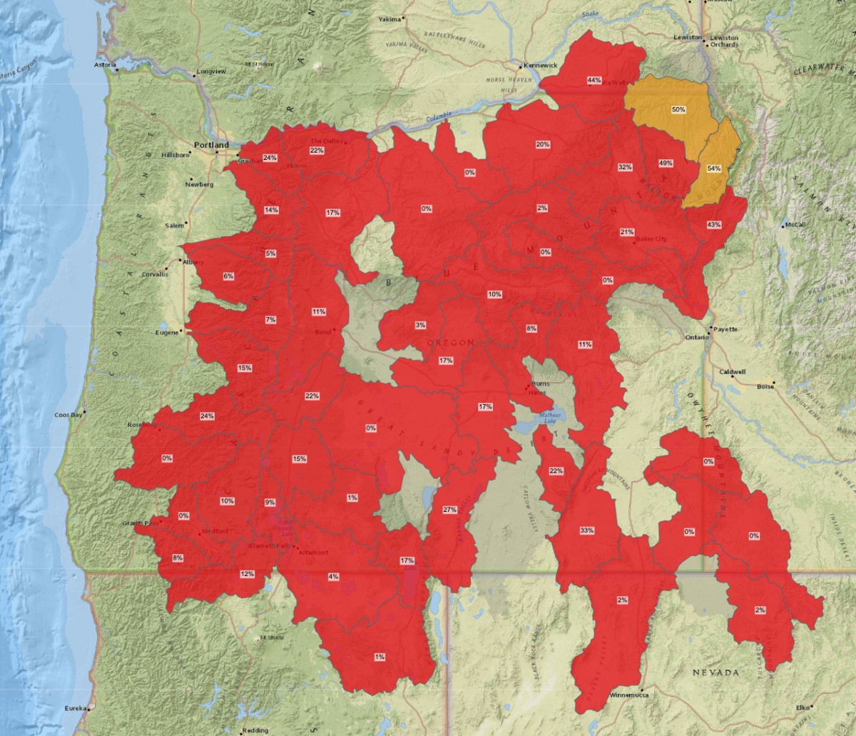
In Oregon, SWE ranges from 54 and 50 percent of median in the eastern Wallowa and northeastern Blue Mountains, to 32, 21, 20, 10, 2 and 0 percent in the rest of the Blues, 33, 27, 22, 17, 8, 2 and 0 percent in the Basin and Range/Great Basin Province, to 30 and 24 percent on either side of Mount Hood, to the low 20s, teens and below down the spine of the Cascades.
Caveats: More snow could still fall. Peak snowpack varies year to year, and it varies by subbasin, from March 11 in the Clackamas watershed, to March 17 in the upper John Day, to March 28 near Crater Lake, to April 9 in “Oregon’s Alps.” Spring rains could help keep things moist and pad the state’s many reservoirs. And June-uary could come early and stay late, keeping things cloudier and cooler, at least west of the Cascades.
But today’s reading means warnings earlier this winter have likely come home to roost.
“Oregon snowpack continues to worsen,” reported Portland TV station KOIN six days ago; “Oregon snowpack at lowest levels in more than a decade, raising wildfire risks,” headlined KGW three weeks ago; “Oregon’s record low snowpack is not likely to recover, scientists say,” OPB grimly headlined six weeks ago, following up on a January 14 piece, “Low snowpack around Oregon leads to concerns about dry conditions this summer.”
And coming on the backs of a warmest fall on record, December’s very strong atmospheric river, another snowpack-wilting AR, and a record-warm-tying winter, and with the odds of a strong El Nino later this year, it all has me fretting about how low the creeks are gonna flow, and how warm they’ll be as spring Chinook and summer steelhead return now and through the coming months, and when fall kings and coho come home to spawn later on.
Fretting, of course, is my natural habitat. But I’ve seen this movie before too, and it’s not my favorite.
All winter I’ve been watching the NWWC snowpack maps, Alert West live cams perched on mountains and buttes, USGS river gauges. It’s left me remembering 2015’s huge sockeye dieoff at Drano and the mid-Columbia, prespawn mortality of spring Chinook in Willamette tribs, and hoot owl fishing restrictions.
It’s way too early to assume those will automatically happen again, but I’m worried. Stay tuned.
