Western Washington’s driest summer on record, as well as one of its warmest, has left a number of streams running at all-time lows as fall salmon begin to return to them.
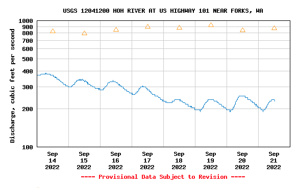
The Hoh, Upper Quinault, Hoko and Naselle on the coast, Duckabush on the east side of the Olympic Peninsula, Tilton in the South Cascades foothills, and the North, Middle and South Forks of the Snoqualmie in the Central Cascades are all flowing at their lowest levels ever recorded for September 21st, per USGS stream gages, while a number of other rivers are at “much below normal” flows for this time of year.
Together they represent a mix of rain- and rain-and-winter-snow-fueled systems that are bordering on E.
The Hoh by Highway 101 is reading 231 cubic feet per second early this afternoon, nearly 40 percent lower than the old minimum mark for this date over 61 years of record and set in 2005, and essentially a quarter of average.
The Nooksack at Ferndale is running at 723 cfs, just half of the median flow over 55 years for this river system draining Mt. Baker.
And the mainstem Snoqualmie near the falls has flatlined into the low 300 cfs range, well below the median flow of 722 cfs over six decades.
It all had a longtime source texting me earlier this week in alarm; “Why is no one talking about the daily low-flow records?” they wondered, concerned about how returning coho and Chinook would navigate the bony waters.
In an emergency rule change notice yesterday reopening the Cascade near Marblemount, WDFW did note the Skagit tributary “is running extremely low” and asked hatchery coho anglers to “refrain from fishing in holes with holding Chinook or runs with spawning Chinook to protect the resource.”
While that warning is as much about protecting salmon as minimizing fishery impacts on the ESA-listed stock that the agency is now more heavily monitoring for, the danger for early-season-spawning salmon is primarily from atmospheric rivers that scour away redds the fish were forced to dig in parts of the river subject to the strongest flows.
To be clear, this is also that point of the year when Westside stream flows just naturally bottom out, the pinchpoint between when the past winter’s snows have mostly if not entirely melted off and the first fall rains have yet to arrive.
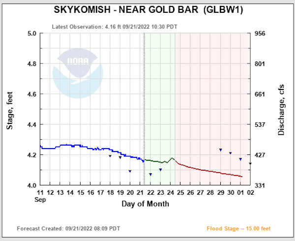
USGS data shows that on average flows begin to tick back up September 12 on the Skykomish at Gold Bar, September 14 on the lower Nooksack, September 15 on the Hoh.
Not so this year, though.
The record lows are surprising given strong spring precipitation, but it’s also been dry ever since.
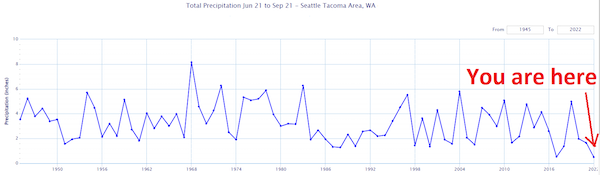
The National Weather Service in Seattle this morning tweeted that the June 21-September 21 precipitation total at SeaTac Airport was .50 inch, “the driest on record,” beating out 2017 by two one-hundredths of an inch.
It would have been by a much wider margin, relatively speaking, if not for rain that fell September 16, providing a third of that half inch, federal forecasters pointed out.
They also produced a table that showed the previous driest summers all had two and a half to three times as much rain, according to records that go back to 1945.
July-August temperatures were also hotter than average, ranging from the warmest ever to third warmest at stations west of the Cascades, per state climate monitors.
It all has me remembering a photojournalism project I did during summer 2015’s horrifically low flows, when The Blob robbed the Cascades of winter snowpack, precipitation that tended to fall as rain instead.

My youngest and I poked around the Sky as it dribbled along at 425 cfs in mid-July, shockingly twice as low as the previous minimum for that day. This morning the Gold Bar gage shows it running 2 cfs more, 427.
I’d worried about how low the Sky would go that year, but if I recall correctly, an unusually powerful-for-late-August storm helped revive flows.
This summer saw something like the opposite, an unusual east wind that brought low humidity and a wildfire in the form of the 10,000-acre Bolt Creek Fire ripping across the flanks of Grotto Mountain, Eagle Rock and Mt. Baring.
With its smoke again choking the Sky Valley, I’ll leave it up to far smarter and scientifically minded folks than myself to try and clear the air about whether it’s all a climate change signal or not.
But I do know that extreme low flows so close to the inevitable arrival of atmospheric rivers, and the apparently increasing frequency of that, is not a recipe for success for salmon.
I’m recalling the infamous “The Day of the Deluge,” October 20, 2003, which dumped 10 inches of rain on Glacier Peak and crushed that year’s Skagit pink run for six years, and fall 2015’s four floods that depressed humpy runs across Puget Sound for a couple runs.
Of course this isn’t a humpy year and coho spawn later into fall, but at this moment it all bears close watching as Chinook are on the gravel.