


Update 1:25 p.m., December 18, 2025:
• WDFW reports that public access to Fir Island reopened at noon today. The island, located at the mouths of the Skagit River, is home to the agency’s Headquarters (Wiley Slough), Fir Island Farm Reserve and Skagit Estuary Units of the Skagit Wildlife Area, which are reopening as road conditions allow.
• WDFW warns that standing water and road and ramp issues may still challenge users of the wildlife areas, and that on the island itself, road closures, emergency operations, debris and other factors may remain, and advises checking with Skagit County Fire District #3.”
• Also note that the Debays Slough Unit of the wildlife area, including the swan reserve, remains closed until the county lifts its closure, according to WDFW. WDFW has been able to assess flood damage there, but there’s no estimated public reopening time at this point.
BY ANDY WALGAMOTT, NORTHWEST SPORTSMAN MAGAZINE
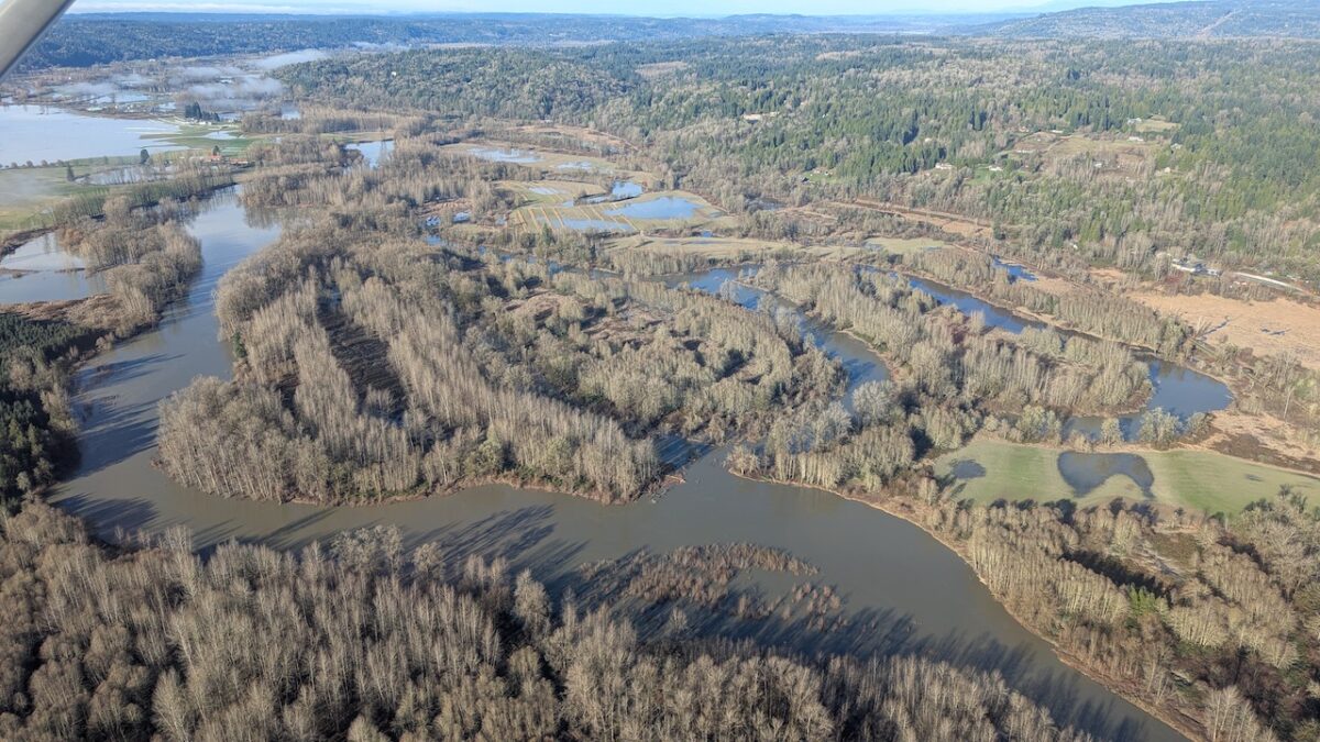
Record flooding across parts of Western Washington dealt some WDFW facilities a blow, with significant damage reported to a fishway and a pair of boat ramps, while some coho smolts at a hatchery self-released early after their rearing pond was overtopped by high water, but the big concern is for how it affected wild salmon spawning beds.
“This record-setting flood event will likely have severe impacts on salmon, particularly eggs laid earlier this fall, many of which will be lost due to scour from floodwaters or buried under heavy sediment. As a result, there will be affects to salmon returns in 2027-2029,” reported Chase Gunnell, an agency spokesman in Mill Creek, late this morning.
The back to back lashings of the atmospheric river that flooded homes, towns and valleys throughout Puget Sound and saw the drowning death of one man in recent days led to immense flows raging out of the Cascades last week – 114,000 cubic feet of water per second on the Skykomish River at Gold Bar, 152,000 cfs on the Skagit River at Concrete – and those extraordinarily powerful currents are likely to have rearranged river beds and the smaller gravels that salmon spawn in.
Gunnell said impacts will vary by watershed and species, but mainstem-spawning spring and fall Chinook “likely experienced significant egg mortality that will affect future salmon runs.”
While concerning biologically, that could also lead to fishery constraints down the line, as has been seen in recent years due to low forecasted wild Chinook returns to several systems and the extra restrictions put in place to protect spawning adults.
“Pink salmon and chum salmon were also likely affected,” Gunnell added.
WDFW run reconstructions show how a single flood can knock salmon productivity back for multiple generations. Following the massive mid-October 2003 flood, Skagit River humpy escapement went from 876,931 fish that fall to just 85,191 in 2005 and 314,723 in 2007 before climbing back to 1-plus million again in 2009. Four floods in fall 2015 – along with at-sea issues from The Blob – clobbered Pugetropolis pink salmon returns in 2017.
Fish stocks that tend to spawn or live higher in watersheds or in smaller tributaries – coho, sockeye and bull trout – were possibly spared flooding impacts that mainstem spawners like Chinook, pinks and chums are likely to see, but only time will ultimately tell. While many rivers are headed back down to more seasonal levels, some like the Duwamish-Green are forecast to remain at moderate flood stage for the coming week as reservoirs are slowly drained, so surveying will be difficult for biologists.
“The scope of these impacts is not yet fully known and is expected to vary by species, life stage, and location, with some areas more affected than others,” said Gunnell. “WDFW will continue to monitor conditions and fish populations to understand the full extent of these impacts.”
On the hatchery side, he reported that Marblemount on the Cascade River saw “minor flooding” with debris and silt left on the grounds and that coho rearing ponds there had been overtopped, “leading to these fish accessing the river earlier than planned,” but otherwise no major impacts.
To the south, Wallace River and Reiter Ponds in the Skykomish Valley both saw minor flooding but no major impacts. A landslide reported yesterday up the road from Reiter had no impact on the facility.
However, further upstream on the Sky, the fishway at Sunset Falls on the South Fork once again was hit with “significant damage” to the collection area by the base due to the flooding. It will require repair and cleanup before it can be used to capture and transport fish into the upper basin.
As for WDFW lands, Gunnell reports “minimal damage” to the Headquarters Unit of the Skagit Wildlife Area, though Fir Island access is currently being restricted to local residents and law enforcement “due to continued risks of flooding or levee failure.” But they’re keeping a wary eye on the Island Unit, where flooding could impact implementation of a restoration project.
He says a parking lot north of Slater Road serving the Tennant Lake Unit of the Whatcom Wildlife Area is temporarily closed as it is used as a staging area for emergency dike work on the Nooksack River.
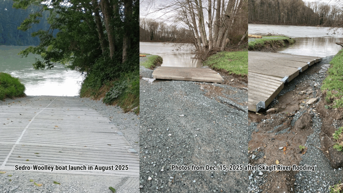
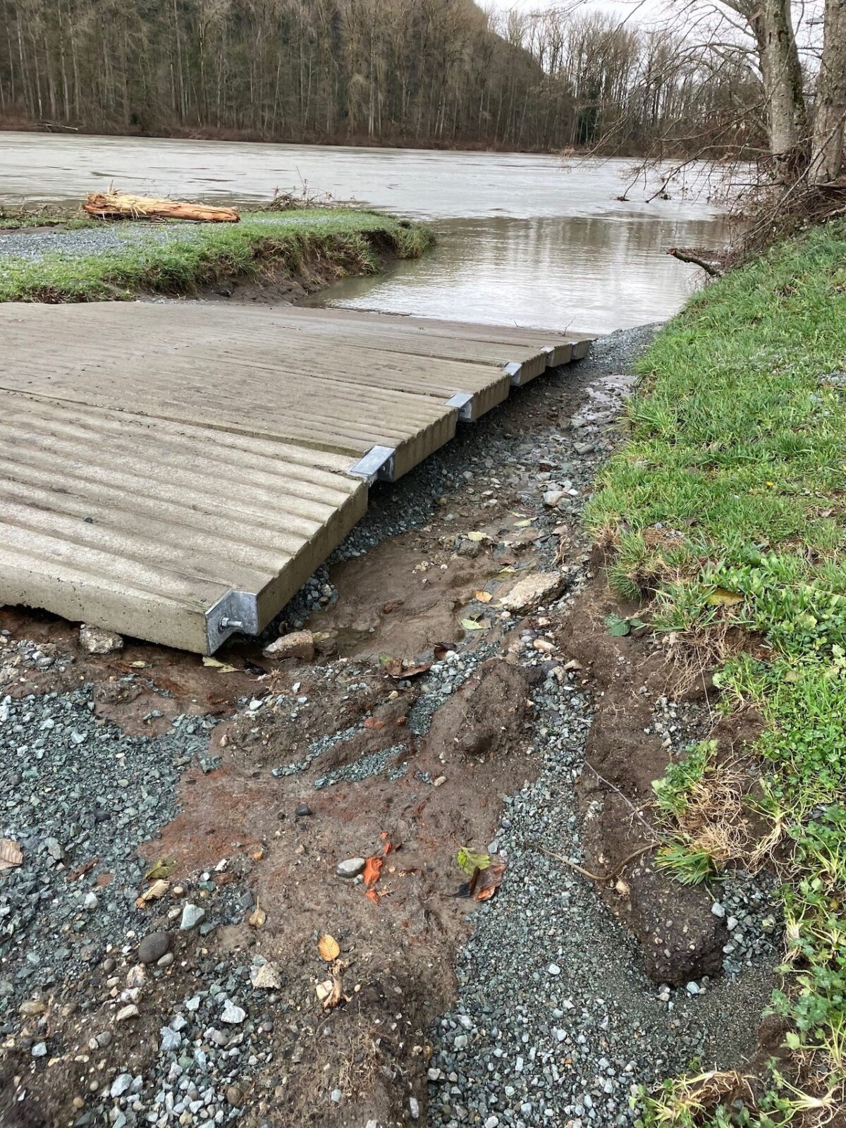
The Sedro-Woolley ramp on the Skagit was “severely damaged” and is being assessed for repairs and to determine whether closing the launch is needed to prevent further issues. According to Gunnell, it was just fixed last summer following 2021 flood damage.
The South Montesano launch on the Chehalis was washed out and “may be closed” for safety and for damage prevention.
Water accesses along the Wenatchee River – which ripped a big hole in Highway 2 and put the east-west cross-Cascades route out of commission through Tumwater Canyon for possibly months, according to Governor Ferguson yesterday – were also “severely impacted” by the flooding, as were accesses along the Icicle.
Gunnell said it’s likely other agency ramps and accesses were damaged and that staffers are surveying sites and coming up with plans to repair them.
He advised hunters, anglers and the general public to refer to WDFW’s website for more info on potentially impacted lands and ramps, and he echoed law enforcement and others in recent days to urge people to respect closure signage.
“We continue to urge the public, including hunters and anglers, to use extreme caution around flood waters. Avoid driving through flooded areas or roadways especially moving water. Mudslides, fallen trees, or debris in roadways may also still occur,” Gunnell said.
If there’s a possible good-news story in all this, it’s on the deeply flooded Snoqualmie Valley, where a 2013 joint restoration project between WDFW, Ducks Unlimited and Wild Fish Conservancy near Stillwater may have helped sop up some of the floodwaters.
“This restoration work allowed for the side channel to absorb some of the river’s water during the recent floods, further increasing flow into the area and creating additional fish habitat,” said Gunnell.
Meanwhile, WDFW Police officers in the swiftwater rescue team assisted in the Skagit Valley to rescue people and pets caught by the flooding. Photos the work are being posted to Facebook.
Correction, 1:13 p.m., December 18, 2026: The range of years in the second paragraph has been corrected to 2027-2029, which is inclusive of the next odd-year pink salmon run, in 2027, as pointed out by a WDFW biologist. The range was originally 2028-2029.
